Makamba Province
This article needs additional citations for verification. (March 2022) |
Makamba Province
Mkoa wa Makamba | |
|---|---|
 | |
| Country | |
| Capital | Makamba |
| Area | |
| • Total | 1,959.60 km2 (756.61 sq mi) |
| Population (2008 census) | |
| • Total | 430,899 |
| • Density | 220/km2 (570/sq mi) |
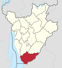
Makamba Province is the southernmost province of Burundi. The province has a population of 430,899 (2008 census) and covers an area of 1,960 km2. The provincial capital is Makamba. Makamba has six communes, many refugees have returned from Tanzania to this province, especially to the communes of Kayogoro, Nyanza lac, Mabanda and Vugizo. This causes a big problem, because there is not enough land for everybody. It is the most fertile province of Burundi.[citation needed]
Location[edit]
Makamba Province is the southernmost province of Burundi. It borders Lake Tanganyika to the west, and Tanzania to the south and east. Bururi Province and Rutana Province are to the north. The central part of Makamba Province is in the Buragane natural region. In the west, some areas are in the Imbo natural region or the Mumirwa natural region. The east of the province is in the Kumoso natural region.[1]
Communes[edit]
It is divided administratively into the following communes:
- Commune of Kayogoro
- Commune of Kibago
- Commune of Mabanda
- Commune of Makamba
- Commune of Nyanza-Lac
- Commune of Vugizo
References[edit]
- ^ Atlas des quatre sites Ramsar, p. 12.
Sources[edit]
- Atlas des quatre sites Ramsar: Localisation et Resources (PDF) (in French), Ministry of Water, Environment and Urbanism, October 2014, retrieved 2024-06-22
4°15′51″S 29°49′0″E / 4.26417°S 29.81667°E
